HYPERSPECTRAL IMAGING
An Introduction to Hyperspectral Imaging
Overview
Hyperspectral imaging is the process of gathering spectral data over a wide, continuous range of wavelengths using a large number of discrete wavelength bands. It can be thought of as the high-def version of multispectral imaging, which may cover the same broad range, but does so using fewer, broader spectral channels.
Basics
Hyperspectral imaging is achieved by using a multiplexed array of detectors, each of which covers a small range of wavelengths within the entire band of interest. Optical thin film bandpass filters are used to define the wavelength range to which each detector responds by allowing the transmission of only narrow range of wavelengths about the center wavelength of the filter.
The spectral range employed by this process spans from UV to IR, with some systems encompassing the complete range from 300nm to 2500nm. The desired wavelength range is divided into many discrete wavelength channels. The greater the number of channels, the higher the resolution that is achieved. A typical commercially-available system might use upwards of 100 channels, with some as high as 450 channels.
The majority of the systems are airborne or spaceborne. The camera samples an area of the surface while in motion, thus the changes in the detected spectrum occur very quickly. Traditional spectroscopy methods cannot acquire data at a fast enough rate to be useful. Herein lies the advantage of hyperspectral imaging. Instead of sequentially scanning each wavelength while sampling the scene, the entire spectrum is acquired simultaneously. If the data were to be viewed in real time it would appear much like a stereo equalizer bar graph display, except that each bar would correspond to a discrete wavelength band rather than a sound frequency.
Benefits
Hyperspectral imaging allows us to ‘see’ our physical world in ways that are not discernable to the human eye, and thus is used in a wide range of industries for a variety of applications including:
- Agricultural Imaging (vegetation indices, weed mapping)
- Biotechnology (fluorescence microscopy, cell biology)
- Environmental Monitoring (CO2 emissions, hydrological formations)
- Food (defect identification, location of contaminants)
- Pharmaceuticals (drug identification, detection of counterfeit and foreign material)
- Remote Sensing (airborne surveillance)
By observing not only the visible but also extending to the SWIR it is possible to more accurately identify surface materials. For instance flowers appear differently to bees than to humans, because bees’ eyes are sensitive to the UV. AstroTurf may look green as grass but in the NIR the materials reflect very differently and do not appear the same. This additional spectral data can not only determine if areas of an image represent vegetation or bare rock but also the rock composition or the type of vegetation and whether it is dry or saturated.
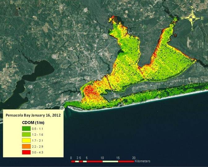
In the image below, the EPA uses hyperspectral imaging to discern the difference between sediment and chlorophyll in the water, in an effort to monitor water quality issues.

Map of chlorophyll-a for Pensacola Bay derived from HICO data. Higher values (yellow and red) indicate high chlorophyll concentrations in the water that suggest algal blooms are present. (EPA/Darryl Keith)
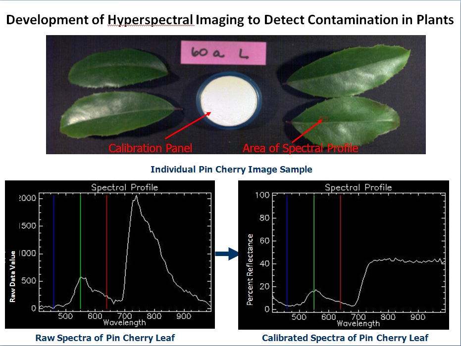
The Naval Research Laboratory (NRL) is involved in developing methods to use hyperspectral imaging devices to monitor plants exposed to the xenobiotic contaminant trichloroethylene (TCE), which is known to negatively affect human health. The image below shows the differences in the spectral profile which would be difficult, if not impossible, to detect with the human eye.

Photo credit: US Naval Research Laboratory
Conclusion
Although hyperspectral imaging has existed for quite some time, recent advances in the technology have made it more affordable and accessible to the research and industrial communities, thus rapidly expanding the breadth and depth of its use.
References:
- http://www.resonon.com/applications_main.html
- http://www.tetracam.com/MS_Database.htm
- http://www.azom.com/article.aspx?ArticleID=8495
- http://www.photonics.com/Article.aspx?AID=56804
- http://spacejournal.ohio.edu/pdf/shippert.pdf
- http://www.exelisinc.com/capabilities/MaterialIdentification/Documents/HSI%20Primer%2010_14.pdf
- https://blogs.nasa.gov/ISS_Science_Blog/2013/10/23/top-space-station-research-results-countdown-eight-hyperspectral-imaging-for-water-quality-in-coastal-bays/
- https://hyspiri.jpl.nasa.gov/airborne
- https://www.ll.mit.edu/publications/journal/pdf/vol14_no1/14_1remotesensing.pdf


